ORLANDO, Fla.
– Your Monday is probably being somewhat interrupted by some fairly spotty showers and thunderstorms, maybe a little extra wind as these rains blow through your area.
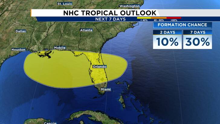
That’s because the broad area of low pressure initially highlighted for low chances of development over the next seven days has now just been given the “invest” title.
Invest 93L is parked right off our eastern shores, trying to gain a little muscle over warm Atlantic water. It has yet to reach the Gulf Stream current, which could encourage a bit more organization as we go through the rest of the day on Monday and especially Tuesday.
[EXCLUSIVE:
Become a News 6 Insider (it’s FREE)
| PINIT!
Share your photos
]
The two primary reasons for this new designation is to allow hurricane hunters to fly into the system and start compiling critical data for the hurricane models as it approaches the state of Florida.
The other reason? The low pressure itself is looking a bit more organized than 24 hours ago, with some quality low-level spin becoming more evident on satellite imagery.
On the positive side, there is some northeasterly wind shear acting to tear down some of the stronger thunderstorms trying to build up near where the vortex is seen forming. This should help to slow down any quick organization as the low crosses over the Sunshine state.
Also, its close proximity to the peninsula may throw it into battle with our daytime thunderstorm set up, and the low itself trying to maximize its environment when generating deeper convection, as it’s called. While this isn’t entirely likely to diminish our invest much, it is worth noting we could see a slowing of anything ramping up ahead of schedule.
Computer models since earlier Monday morning, however, are latching onto the idea of a tropical depression perhaps coming ashore in Central Florida before it plops somewhere in the eastern Gulf.
What does this mean for you?
We’re still anticipating the same general impacts; however, they could be far more “tropical” as opposed to your garden variety showers and storms we traditionally see during a summer afternoon.
The beaches will remain somewhat hostile, especially if winds around our low pressure continue to increase. Our heaviest rainfall totals could occur along the southern side of this feature, especially given its “tilted” appearance, thanks to those winds helping to shear it from becoming a full/circular tropical storm.
Some of these incoming bands of storms could also get strong. The Storm Prediction Center has the entirety of our beautiful state highlighted for a marginal risk of severe storms.
The Weather Prediction Center also continues to carry an elevated risk for excessive rainfall. The developing bands of thunderstorms have the capability of dropping a LOT of water all at once, which could create some inland flooding, hazardous road conditions, and lots of ponding in your area, especially if you’ve already received some large amounts of rain up to this point.
Hurricane Hunters are tasked with a mission inside our invest on Tuesday.
This could potentially give our system a bit more time over water to further organize. It will be very interesting to see what they discover, especially if it does maximize its ability to take advantage of the very warm waters beneath it and some favorable upper level flow acting as an exhaust mechanism.
Get tropical weather updates from Jonathan Kegges.