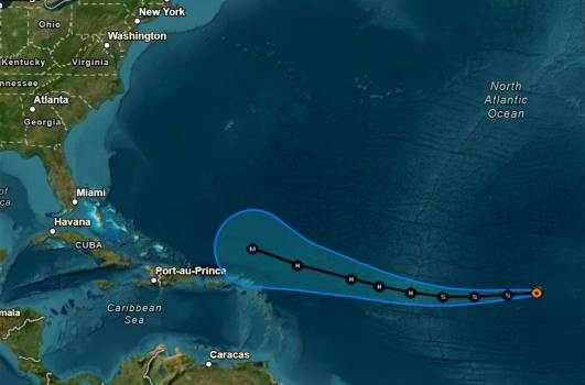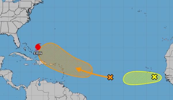
While the National Hurricane Center monitored two tropical waves that might follow Hurricane Erin’s route, the hurricane weakened to a Category 2 hurricane on Tuesday as it moved northward in the Atlantic, prompting coastal advisories for Florida.
The center of Erin was 665 miles southwest of Bermuda and 720 miles south-southeast of Cape Hatteras, North Carolina, as of the NHC’s 8 a.m. update. It was moving northwest at 7 mph with maximum sustained winds of 110 mph, and it was no longer a major hurricane for the first time since Saturday.
Winds won’t be an issue because the storm’s closest approach to Florida, according to Melbourne’s National Weather Service, will be east of Cape Canaveral early on Wednesday.
Starting at noon tomorrow, August 19, a High Surf Advisory has been issued due to localized beach erosion along the Volusia and Brevard County coasts, as well as strong breaking waves of 5 to 8 feet. Because of the severe surf conditions, swimmers should stay out of the water.VpSDSy17G1 #FLwxpic.twitter.com
August 19, 2025, NWS Melbourne (@NWSMelbourne)
However, this will have a major impact on boating and the seashore. Particularly during the high tide cycles, building swells from Hurricane Erin will result in a persistently high danger of rip currents and breaking waves of 5 to 8 feet, creating harsh, pounding surf with some beach and dune damage, according to the NWS.
A high surf advisory is in effect for the coastlines of Volusia and Brevard starting at midday, and more is anticipated to the south early on Wednesday when Erin moves north of the protective Bahamas bank. This falls between 5-7 a.m. and 5-7 p.m.
According to the NWS, it is not recommended to enter the surf due to the generally hazardous conditions at the nearby beaches.
As a precaution, Volusia County cleared its beaches of garbage cans, portable restrooms, and other items. The county cautioned that the availability of beach driving may potentially be impacted by tidal conditions.
With a significant risk of rip currents predicted throughout the week and perhaps into the weekend, Florida’s seaside danger will not go away even after Erin leaves.
On its predicted route, the hurricane itself is not anticipated to reach land.
According to NHC senior warning coordinator Robbie Berg, a shift toward the north-northwest with an increase in forward speed is anticipated today, followed by a northward move on Wednesday and a northeastward motion on Thursday. The center of Erin is expected to move over the western Atlantic between the east coast of the United States and Bermuda on Wednesday and Thursday after passing east of the Bahamas today and tonight.
Tropical storm watches were still in effect for the central Bahamas and the U.S. coast from Beaufort Inlet to Duck, North Carolina, including Pamlico Sound, while tropical storm warnings were also in effect for the southeast Bahamas and Turks and Caicos. A storm surge watch is also in effect from Cape Lookout to Duck, North Carolina, with waves as high as 2-4 feet predicted if the surge occurs during high tide.
As more tropical storm watches and warnings might be needed later today, the NHC advised people in the northwest Bahamas, Bermuda, and the mid-Atlantic and southern New England coasts of the United States to keep an eye on Erin’s path.
At 11 a.m. Friday, the storm reached 75 mph winds, making it the season’s first Atlantic hurricane. However, in a single day, it rapidly intensified, reaching sustained winds of up to 160 mph, and became a devastating Category 5 hurricane. After moving just north of the northern Leeward Islands, it started to weaken late Saturday.
Compared to earlier forecasts, its route has moved slightly to the west on Tuesday.
Through Tuesday morning, it had swung up and down as a major storm before reverting to Category 2.
The indications regarding Erin’s future intensity are conflicting. According to Berg, some re-intensification should be supported by more favorable environmental shear and upper-level divergence in the next 24 to 36 hours. However, the hurricane’s broad structure may prevent significant intensification, and Erin’s slow pace and size may cause some colder water to upwell.
Although it is predicted to start interacting with a frontal barrier by Friday and turn into an extratropical storm by Saturday, Erin may continue to be a hurricane for five more days.
However, the U.S. East Coast will be more concerned about its expanding wind field. Tropical-storm-force winds radiate out 205 miles from its core, while hurricane-force winds reach up to 80 miles.
According to Berg, the new forecast now calls for tropical storm force winds to pass very near the southern New England coast and the Mid-Atlantic later this week. Much of the western Atlantic will experience choppy seas due to Erin’s growing wind field.
Through Tuesday night, trailing bands from Erin could bring 1-2 inches of rain to the Bahamas and Turks & Caicos, with some places possibly receiving up to 8 inches, posing a risk of flash and urban flooding.
As it moves north, life-threatening surf and rip conditions will intensify along the U.S. East Coast, Bermuda, and Atlantic Canada, while starting late Wednesday, tropical storm conditions may be likely over North Carolina’s Outer Banks.
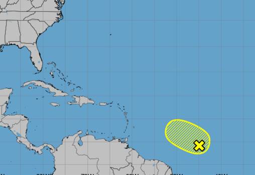
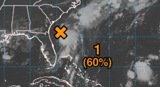
In other news, two tropical waves that are coming after Hurricane Erin are causing increasing anxiety.
With a wide region of erratic showers and thunderstorms, the closer of the two was nearing the Caribbean’s Leeward Islands in the central tropical Atlantic as of the NHC’s 8 a.m. tropical alert.
A tropical depression may form by the end of the week or weekend, according to experts, as environmental circumstances seem favorable for the system’s steady growth. On Friday, this system is expected to hit the area of the Leeward Islands as it moves west to west-northwest at a speed of roughly 20 mph across the central tropical Atlantic.
It had a 10% probability of developing during the next two days and a 60% chance within the next seven, according to the NHC.
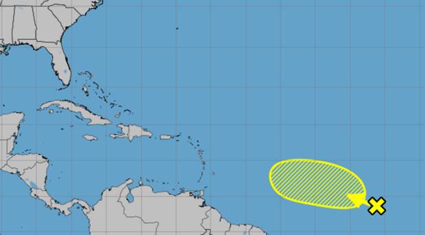
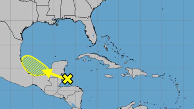
A tropical wave with a concentrated area of showers and thunderstorms is located a few hundred miles southeast of the Cape Verde Islands.
As the system moves westward at about 15 mph, forecasters said the environmental conditions look generally favorable for further development over the following few days. This system may run into a less favorable climate toward the conclusion of this week, which would limit its future development opportunities.
It had a 30% chance of developing within the following two to seven days, according to the NHC.
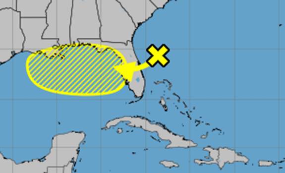
Tropical Storm Fernand would be the name of either system if it developed into a named storm. Gabrielle is the next name on the Atlantic hurricane season list.
The National Oceanic and Atmospheric Administration recentlyupdatedits season forecast, now calling for 13-18 named storms for the year, of which five to nine would grow into hurricanes. Of those, two to five would grow into powerful hurricanes with a maximum intensity of Category 3.
Hurricane season lasts six months, from June 1 to November 30. It peaks from mid-August to October.