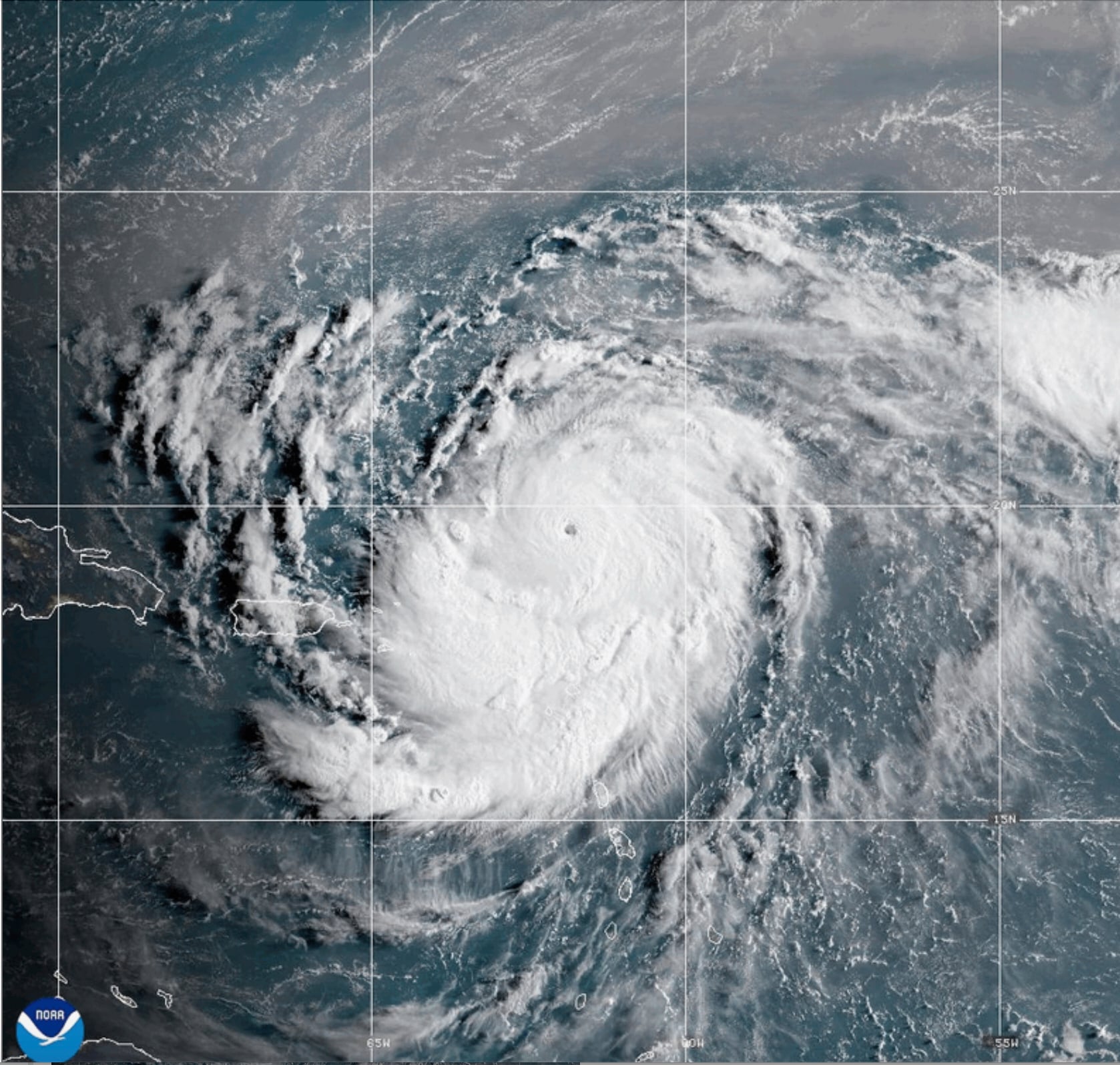
MiamiThe National Hurricane Center reported that Hurricane Erin quickly strengthened from a tropical storm to a Category 5 storm in Atlantic waters just north of the Caribbean on Saturday.
The core of the compact storm was not predicted to make landfall, but as it became larger, it posed a hazard of flooding rainfall across the northeast Caribbean.
Suggested Videos
In just one day, Erin, the first Atlantic hurricane of 2025, intensified from a tropical storm to a Category 5 hurricane. Its maximum sustained winds more than doubled to 160 mph (255 kph) by late Saturday morning.
Erin developed into a very strong hurricane, according to Mike Brennen, director of the National Hurricane Center in Miami, whose winds reached 60 mph (96 kph) in roughly nine hours.
In an online briefing, Brennan stated, “We anticipate seeing Erin peak here in intensity fairly soon.”
As the storm experiences more wind shear and potentially absorbs more dry air, the Hurricane Center predicted that Erin would become slightly weaker late Saturday or early Sunday. Forecasters, however, indicated that it will continue to be a powerful hurricane until the middle of the week.
Erin is near enough to the ground to cause landslides and flooding.
On Saturday afternoon, the hurricane was 110 miles (180 kilometers) north of Anguilla and was traveling at 16 mph (26 kph) west. The National Hurricane Center predicted that the storm’s center would stay at sea and pass 145 miles (233 kilometers) north of Puerto Rico.
The hurricane center warned that heavy rain in some places might cause mudslides, landslides, and flash flooding, and tropical storm watches were issued for St. Martin, St. Barts, and St. Maarten.
In the southeast Bahamas and the Turks and Caicos Islands, gusts of wind with tropical storm force were possible.
Erin was predicted to double or perhaps treble in size in the days ahead, while being compact and having hurricane-force winds 30 miles (45 km) from its center.
Although the storm’s eye is expected to stay far offshore, Brennan warned that strong rip currents could impact the U.S. East Coast from Florida to the mid-Atlantic next week.
From tropical storm to Category 5, an amazing race
According to Michael Lowry, a hurricane specialist and storm surge expert, Erin intensified at a rate that was extraordinary for any season, much less August 16.
Just four further Category 5 hurricanes have been observed in the Atlantic on or before August 16, according to Lowry.
The hurricane season usually peaks around mid-September, with the strongest storms usually developing later in the year.
In October 2005, the National Hurricane Center issued advisories for Hurricane Wilma, which in less than 24 hours grew from a tropical storm to a Category 5. Before making landfall in Florida, Wilma weakened to a Category 3 storm. Additionally, Hurricane Felix in October 2007 went from a tropical storm to a Category 5 hurricane in just over a day.
According to Dan Pydynowski, senior meteorologist at AccuWeather, a private forecasting firm, Erin is one of 43 hurricanes that have ever achieved Category 5 status in the Atlantic.
Although they are undoubtedly uncommon, Pydynowski stated that this would be the fourth consecutive year that the Atlantic basin has experienced one. Hurricanes need to be far from land, have very warm ocean water, and have little to no wind shear in order to attain such strength, he said.
Scientists claim that a rising climate causes storms to intensify more quickly.
Scientists have connected climate change to the Atlantic hurricanes’ increased strengthening. Ocean temperatures are rising because to global warming, which also causes the atmosphere to store more water vapor. Warmer oceans provide hurricanes with fuel to intensify and release more rain.
Rapidly intensifying storms make it more difficult for meteorologists to forecast and for government organizations to prepare for catastrophes.Additionally, Hurricane Erick, a Pacific storm that hit Oaxaca, Mexico, on June 19, intensified quickly, tripling in strength in less than a day.
Erin is the first hurricane and the fifth named storm of the Atlantic hurricane season, which begins on June 1 and ends on November 30.
With six to ten storms predicted, three to five of which are likely to reach major status with gusts above 110 mph (177 kph), the 2025 season is predicted to be exceptionally active.
On Saturday, residents and visitors to San Juan, Puerto Rico, went shopping, exercising, and taking walks as usual. Restaurants were crowded, and individuals were observed in the water at Ocean Park and Ultimo Trolley beaches in contravention of the beach closure advisories. However, parents prevented their kids from swimming.
Because the sky seemed quiet, Sarah Torres and Joanna Cornejo, who were traveling from California for a Bad Bunny show, said they chose to go to the beach and wade into the sea.
We went outside since the weather appeared to be fine, Torres stated.
As a precaution, the Federal Emergency Management Agency and other U.S. government agencies sent over 200 personnel to Puerto Rico. According to Ciary P. Rez Pea, the housing secretary for Puerto Rico, 367 shelters have been assessed and are prepared to operate if necessary.
As a precaution, Bahamas officials set up a few public shelters and asked citizens to keep an eye on the hurricane.
According to Aarone Sargent, managing director of the Bahamas disaster risk management organization, these storms are extremely erratic and capable of abrupt movement changes.
___
Bynum reported from Georgia’s Savannah. Contributions came from Ivelisse Rivera in San Juan and Isabella O’Malley in Philadelphia for the Associated Press.
___
Several private foundations provide funding for the Associated Press’s coverage of the environment and climate. All content is the exclusive responsibility of AP. Visit AP.org to find funded coverage areas, a list of supporters, and AP rules for dealing with philanthropies.


