Location |
1095 miles E of The Northern Leeward Islands |
Wind |
50 mph |
Heading |
W at 16 mph |
Pressure |
29.59 |
Coordinates |
46.6W, 16.3N |
Suggested Videos
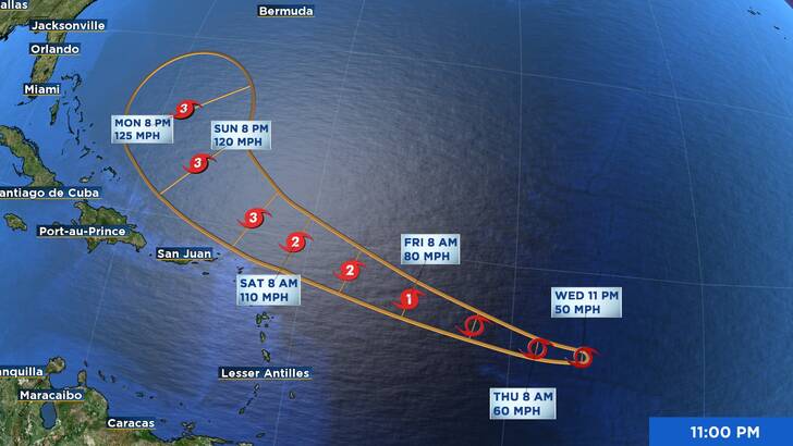
Tropical Storm Erin’s center was situated close to latitude 16.3 North, longitude 46.6 West, around 1100 PM AST (0300 UTC). Erin is traveling at around 16 mph (26 km/h) westward. With a west-northwestward motion starting Thursday evening and extending into the weekend, this general motion is predicted to last until Thursday. Over the weekend, the center of Erin is expected to pass close to or slightly north of the northern Leeward Islands, according to the predicted track.
With greater gusts, maximum sustained winds stay close to 50 mph (85 km/h). The following day or so is expected to see a gradual strengthening, with Friday and Saturday perhaps seeing more intense intensification.
Winds with tropical storm force can reach up to 60 miles (95 km) from the center.
A minimum central pressure of 1002 mb (29.59 inches) is estimated.
No coastal warnings or watches are in force.
Puerto Rico, the Virgin Islands, and the northern Leeward Islands should keep an eye on Erin’s development.
The Tropical Cyclone Discussion’s AWIPS header MIATCDAT5 and WMO header WTNT45 KNHC include the main messages for Erin.
SURF: By this weekend, Erin-generated waves will start to impact areas of Puerto Rico, the Virgin Islands, and the northern Leeward Islands. It’s likely that these swells may result in potentially fatal surf and rip current situations. Please refer to the weather forecast office’s goods in your area.
Here is a graphic representation of the risk of rip currents in the United States: hurricanes.gov/graphics_at5.shtml?ripCurrents